

History on Long Term Vision and Plan: Standing Committee on Procedure and House Affairs—February 27, 2020
Document navigation for "Standing Committee on Procedure and House Affairs: February 27, 2020"
On this page
The Parliamentary Precinct
Key messages
- The Minister of Public Services and Procurement Canada (PSPC) is the official custodian of the buildings and grounds of the precinct, responsible for their care, upkeep, structural integrity and appearance; for the management of major renovations and new construction; and, for provision of general purpose accommodation
- The precinct is composed of 35 Crown-owned buildings and associated lands, included 28 designated federal heritage properties
- The precinct includes the parliamentary triad (West Block, Centre Block, and East Block), and leased properties throughout the National Capital Region
- The precinct also includes lands south of Wellington and north of Sparks (between Bank and Elgin), these were expropriated in 1973 for future use by Parliament.

Map indicating the boundary of the Parliamentary Precinct.
This map indicates the boundary of the Parliamentary Precinct which encompasses all lands south of the Ottawa River and north of Wellington Street from the Rideau Canal to Kent Street, and all lands north of Sparks Street and south of Wellington Street from Elgin Street to Bank Street. There is also a Food Production Facility out of the downtown core, at 1170 Algoma Road.Legend
- Parliament Hill
- Sparks and Wellington streets (blocks 1, 2, and 3)
- Government Conference Centre (Senate of Canada building) and Rideau Committee rooms
- Out of downtown
The Long Term Vision and Plan
In this section
Key messages
- Parliament and the government had been struggling on how best to address the poor condition of the Parliament buildings for over 50 years
- Over the years, a series of events and direction provided by successive governments and parliaments have influenced the development of the Long Term Vision and Plan (LTVP) for the Parliamentary Precinct
- The LTVP is a strategy to modernize and restore the Parliament buildings to meet the needs of a 21st century Parliament, and to preserve heritage for Canadians by
- modernizing accommodations, while preserving the heritage character of the buildings
- restoring and renewing the iconic heritage buildings, while ensuring that the investments are made responsibly, reducing their environmental impact, and providing good value and benefits for Canadians
- creating a safe and secure place to work, while ensuring that parliament remains open and accessible for business and visitors
- A key objective of the LTVP has been addressing the triad, while restoring heritage rather than constructing new buildings
History of the Long Term Vision and Plan
Long term planning of the Parliamentary Precinct began in 1912. The plans prepared by Jacques Gréber in 1938 and 1950 had the most enduring influence, addressing the picturesque arrangement of the buildings and landscape and their relationship to the town south of Wellington Street. Over the years, a series of events and direction provided by successive governments and parliaments, have influenced planning and development in the Parliamentary Precinct. As site and building conditions continued to change and parliamentary requirements evolved, it was essential that long term planning of the precinct be undertaken regularly to ensure that plans remained current, relevant and effective. Such a review was undertaken in 2001. It was also during this review that the phrase “Long Term Vision and Plan” was coined.
First approved in 2001, the Long Term Vision and Plan set out 3 core objectives:
- restore the aging and deteriorated buildings in the Parliamentary Precinct
- address a longstanding shortfall of adequate parliamentary accommodations
- modernize the buildings to meet the needs of a 21st century Parliament
The 2007 Long Term Vision and Plan
In response to a lack of consensus on key priorities, and delays and overruns for major projects (for example, Library of Parliament), an updated plan was approved by parliament and government in 2007. The plan was accompanied by a new implementation framework that shifted from a rigid 25-year master plan to rolling 5-year programs. The rolling programs of work approach offers greater flexibility to respond to emerging priorities and address building conditions, greater accuracy in developing project costs and schedules, and enables the government to set long-term direction while establishing clear priorities at 5-year intervals.
The revised LTVP prioritized the rehabilitation of the 3 main Parliament buildings—the West, Centre and East Blocks—with the core objective to create the swing space and interim accommodation necessary to vacating the Centre Block and launching its historic rehabilitation.

Map of the Parliamentary Precinct outlining the series of moves required to implement LTVP rehabilitation projects.
A map of the Parliamentary Precinct outlining the series of moves required to implement LTVP rehabilitation projects. Arrows on the map identify the locations of swing space.The objective of the 2007 LTVP was accomplished with the 2018 transition of parliamentary operations out of Centre Block and into the West Block, Senate of Canada Building, and Visitor Welcome Centre phase 1.
The transition of parliamentary operations from Centre Block to their new facilities was one of the most successful and critical LTVP milestones to date and given its national significance, it was also reflected in the minister’s mandate letter.
Transforming the precinct into an integrated campus
The Long Term Vision and Plan has, until recently, focused on creating the swing space needed to vacate the Centre Block and launch its historic rehabilitation. [Redacted]
With parliamentary operations now taking place in the West Block and the Senate of Canada Building, PSPC’s focus has shifted to the rehabilitation of Centre Block, as well as the rehabilitation of remaining assets still in need of intervention in view of creating an integrated parliamentary campus. PSPC is therefore advancing the redevelopment of the 3 city blocks across from Parliament Hill, along Sparks and Wellington streets. The redevelopment of these blocks are also central to the restoration and modernization of other key assets, including the East Block and Confederation buildings.
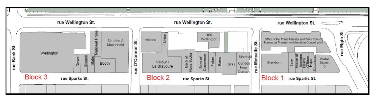
A map of the Blocks 1, 2 and 3 which are bounded by Wellington, Sparks, Elgin and Bank streets.
A map of the Blocks 1, 2 and 3 which are bounded by Wellington, Sparks, Elgin and Bank streets. All 3 blocks are bound by Wellington to the north and Sparks to the south:
- block 3 is located between Bank and O’Connor streets, and includes the following buildings: Wellington, Dover, Brouse, Salter, Booth, Sir John A Macdonald, and National Press
- block 2 is located between O’Connor and Metcalfe streets, and includes the following buildings: Victoria, Valour, Bank of Nova Scotia, Bank of Commerce, Fisher, Bate, Birks, Canada Four Corners, Marshall, 100 Wellington, and Union
- block 1 is located block between Metcalfe and Elgin streets, and includes the following buildings: Blackburn, Saxe, House of Norcano, Nelms, O’Brien, Hope Chambers, Postal Station B, and the Office of the Prime Minister and Privy Council
The integrated campus approach will support improved efficiency and functionality for a modern parliament and Office of the Prime Minister and Privy Council, and the adoption of a holistic and consistent approach for:
- centralized material handling
- secure tunnel infrastructure
- integrated information management/information technology (IM/IT)
- enhanced physical and cyber security
- making the precinct a model for sustainability and accessibility
The transformation of the precinct into an integrated campus will begin with the redevelopment of the block bounded by Wellington, O’Connor, Sparks, and Metcalfe streets, referred to as Block 2. This will include the construction of 2 new buildings to support the immediate and long-term accommodations of parliament and the transformation of the former US embassy located at 100 Wellington Street into a national space for Indigenous Peoples. [Redacted]. An advanced procurement notice for a design competition for the project was posted on Buy and Sell in January 2020. The request for qualifications for interested firms is expected for March, and the design competition is expected to launch in summer 2020 with construction to follow.
Future phases of the redevelopment will transform the remaining 2 blocks, including the restoration and modernization of the Office of the Prime Minister and Privy Council.
The approved program of work for the Long Term Vision and Plan will continue into the 2030s.
Document navigation for "Standing Committee on Procedure and House Affairs: February 27, 2020"
- Date modified: